


Tornado risk puts St. Louis and Midwest cities on edge
Wednesday, June 18, 2025 – New York local time: 2:00 p.m. EDT
St. Louis is now under high alert, joining Lansing, Grand Rapids, Ann Arbor, Alton, Edwardsville, Belleville, and Bowling Green as a powerful tornado threat continues to sweep through the Midwest. What started as a quiet summer morning has suddenly escalated into a high-stakes emergency, with storm cells developing quickly and travel plans unraveling in real time.
Emergency sirens have echoed across Belleville and Edwardsville, while weather monitors show Lansing and Grand Rapids facing similar threat levels. Residents in Ann Arbor and Bowling Green are now keeping a close watch on the sky.
This is not just another storm. The system now sweeping through the region is fast-moving, unpredictable, and could disrupt air travel, tourism, and public safety across Missouri, Illinois, and parts of Michigan.
Tornado watch triggers regional travel alert in St. Louis
By early Wednesday morning, the National Weather Service issued a tornado watch covering dozens of counties in Missouri and Illinois through 4:00 p.m. CDT. The alert follows a confirmed tornado touchdown in northwestern Calhoun County, Illinois, early today—an ominous signal that this system is gaining strength.
As summer tourism hits its peak, this weather event is already rattling the local travel industry. Airports, hotels, and tour operators across the St. Louis region are now scrambling to adjust schedules, notify guests, and prepare for potential closures. Many airlines are actively tracking thunderstorm activity and warning of possible delays through the evening hours.
Where the threat is most dangerous: counties at risk
The tornado watch zone spans a large section of the Midwest, with particularly vulnerable counties under close observation for hail, damaging wind gusts, and rotating supercells.
In Missouri, areas under watch include: St. Louis City, St. Louis County, St. Charles, Jefferson, Lincoln, Cape Girardeau, Perry, Madison, Pike, St. Francois, Ste. Genevieve, and Bollinger.
In Illinois, the affected counties are even more extensive: St. Clair, Madison, Calhoun, Monroe, Jersey, Randolph, Macoupin, Clinton, Bond, Marion, Jefferson, Clay, Fayette, Greene, Montgomery, and Washington.
Earlier this morning, a tornado warning was also in effect for Pike County, Illinois, where storm rotation and damage reports have already been confirmed.
Travel and tourism hit hard at summer’s peak
With summer crowds pouring into St. Louis, from concertgoers to conference attendees, the timing of this storm is particularly difficult. A Level 2 and Level 3 risk on the Storm Prediction Center’s 5-point scale has forced event organizers and venue operators to reconsider plans.
Guests staying in downtown hotels are being briefed on shelter-in-place procedures, while regional tour companies are issuing alerts, pushing alternative plans, and working with clients to rebook itineraries as needed.
Air travel remains active but under surveillance
St. Louis Lambert International Airport remains open, but operations are running under storm protocol. Airlines are watching for wind shear, lightning, and visibility drops, especially during the peak storm window between 12:00 p.m. and 10:00 p.m. CDT.
Private aviation and regional carriers are exercising caution, as turbulent conditions pose risks to smaller aircraft. Connecting flights across the Midwest may experience delays or re-routes, especially if Detroit, Chicago, or Kansas City are affected later today.
Major attractions prepare for emergency closures
Across St. Louis, iconic tourist destinations such as the Gateway Arch, Forest Park, the Missouri Botanical Garden, and the St. Louis Zoo are issuing weather bulletins and may adjust operating hours depending on real-time updates.
In rural Illinois and eastern Missouri, destinations in Ste. Genevieve, Calhoun, and Jefferson Counties—known for agritourism and historic trails—are preparing for potential road closures and safety protocols as the storm front moves eastward.
Emotional toll mounts with repeated weather emergencies
After a spring season marked by high winds, flash flooding, and power outages, many residents are emotionally fatigued. The growing pattern of severe weather events is testing the region’s resilience, as both locals and repeat visitors experience the rising tension of yet another tornado threat.
Hotel teams, particularly in St. Louis, are stepping up with reassurance-focused guest service, offering both emergency guidance and empathy as today’s situation unfolds.
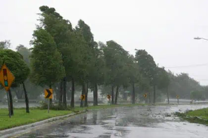
Storm forecast: volatile conditions into the evening
While not all areas under watch will experience direct tornado impacts, the atmospheric setup—with high instability, moisture, and vertical lift—makes it likely that thunderstorms will continue developing quickly.
Forecasters expect the most intense activity between 3:00 and 10:00 p.m. CDT, when temperatures reach into the mid-80s°F (around 29°C) and dew points remain high.
Central Illinois and St. Louis County remain the core areas of concern, though new warnings may emerge as the system shifts throughout the day.
Southern Michigan braces for tornadoes and hail
To the northeast, southern Michigan cities like Lansing, Ann Arbor, and Grand Rapids are preparing for tornado-capable storms this afternoon and evening. Meteorologists predict large hail, strong winds, and the potential for supercell rotation in this corridor, especially between 3:00 and 10:00 p.m. EDT.
Hotels in Ann Arbor and Lansing are instructing guests to stay inside. Detroit Metropolitan Airport remains operational, but with increased delays expected as air traffic controllers monitor weather shifts hour by hour.
Unusual tornado spotted under rainbow in Nebraska
In a rare weather twist, a tornado was observed passing beneath a rainbow in Dickens, Nebraska, earlier today. Although this storm was isolated, it illustrates the unpredictability of today’s weather system—and the broad reach of instability now stretching from the Great Plains to the Great Lakes.
If you’re traveling: vigilance is essential
Whether you’re in St. Louis, Detroit, or Grand Rapids, awareness is key today. Stay off rural highways during storm watches, check airline updates frequently, and follow hotel safety briefings closely.
This is not just a meteorological event—it’s a moment of high impact for travelers, residents, and anyone moving through this vast and vulnerable part of the United States.


