


Weather alert active for Central Pennsylvania this Thursday afternoon
Thursday, July 3, 2025 – Central Pennsylvania is currently under a weather alert issued by the National Weather Service, warning of strong thunderstorms through 3:00 p.m. local time. The advisory affects much of Central Pa., including Perry, Dauphin, Lebanon, Cumberland, Adams, York, and Lancaster counties.
According to meteorologists, scattered but intense thunderstorms are forming across the region, tracking east-southeast at 30 to 35 mph. These fast-moving systems are capable of producing wind gusts up to 55 mph, nickel-sized hail, and torrential downpours. The storms may intensify quickly, and residents are strongly urged to stay tuned to local weather updates throughout the afternoon.
Lightning safety remains critical as storms approach
Every year, lightning strikes the United States approximately 25 million times, with the vast majority of these discharges occurring in summer. Tragically, an average of 20 fatalities are recorded annually due to lightning-related incidents. The risk increases dramatically as a thunderstorm nears and is highest when the system is directly overhead. It only gradually decreases once the storm moves away.
Key lightning safety practices include having a shelter plan, monitoring the sky and sound for warning signs like thunder, and avoiding risky activities outdoors when storms are near. Even once the rain stops, wait at least 30 minutes after the last thunderclap before resuming outdoor activities, as lightning can strike even in a clearing sky.
When indoor shelter is not available, steer clear of elevated ground, isolated trees, open fields, or bodies of water. Always avoid metal objects, as they are excellent conductors of electrical energy, though they do not attract lightning on their own.
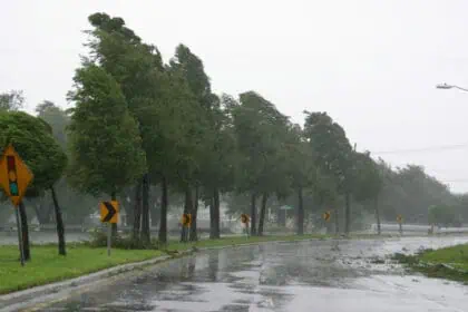
Driving through heavy rain: dangerous road conditions in wet weather
Rain not only obscures visibility but also transforms roads into slick, hazardous surfaces. As storms sweep across Central Pennsylvania, motorists are urged to take the following precautions:
Flooded ditches and culverts can be deceptively powerful—never walk or park near fast-moving water. While driving, increase following distances, especially behind large trucks and buses, whose tire spray can severely reduce visibility. Use headlights even during daylight hours to improve visibility, and be cautious of blind spots.
The first 30 minutes of rainfall are particularly risky, as oil and grime on the road surface mix with water, creating an extremely slippery layer. If your windshield wipers are overwhelmed and visibility drops below safe levels, pull over to a rest area or a guardrail-protected shoulder with your hazard lights activated.
Drivers should also remember that hydroplaning occurs more easily in outer lanes of multilane roads, so the middle lanes are usually the safest during downpours.
A break in the stormy pattern is expected by Friday, as a cold front clears out the instability responsible for today’s thunderstorms. Fourth of July festivities in Central Pennsylvania are likely to benefit from this improving weather pattern.


