


Heavy rainfall expected across Tampa Bay through the Fourth of July weekend
TAMPA BAY, Florida — Forecasters are closely watching a potential tropical system near the Florida peninsula, as deep tropical moisture from the Gulf of Mexico continues to stream into the region, raising rainfall probabilities significantly.
Although the National Hurricane Center currently places low odds on any major development in the next few days, meteorologists warn that the combination of unstable air masses and moisture influx could result in persistent showers and thunderstorms across much of West Central Florida.
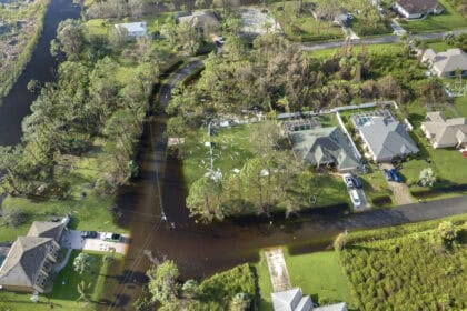
Between now and early next week, parts of the Tampa Bay area could receive as much as 6 inches (152 mm) of rain, according to a Tuesday morning update from the National Weather Service. This prolonged pattern is expected to linger through the Fourth of July holiday, potentially affecting outdoor celebrations across Hillsborough, Pinellas, and Pasco counties.
Daytime highs are forecast to stay near 90°F (32°C), but the humidity and frequent storms will make conditions feel even warmer, especially during afternoon hours when thunderstorm coverage peaks. Evening periods may offer only brief dry breaks, as scattered downpours could persist into the night.
Weather models are still uncertain on whether the disturbance in the southwestern Atlantic or eastern Gulf will organize into a named system, but any circulation, however weak, could enhance rainfall rates and bring gusty winds to coastal areas by the end of the week.
The National Weather Service in Ruskin continues to update advisories for the Tampa Bay region, with flash flood watches possible if rainfall totals exceed forecast thresholds.


