

Strong supercell devastates Cochran, Hockley and Lubbock Counties
On the afternoon and evening of Thursday, June 5, 2025, a powerful supercell thunderstorm carved a path of destruction across the South Plains region of West Texas, generating eight tornadoes and causing widespread wind and hail damage, especially in the City of Lubbock.
The National Weather Service in Lubbock dispatched three survey teams to analyze the aftermath, confirming that the supercell affected Cochran, Hockley, and Lubbock Counties, before weakening as it moved into Crosby and Garza Counties late that night.
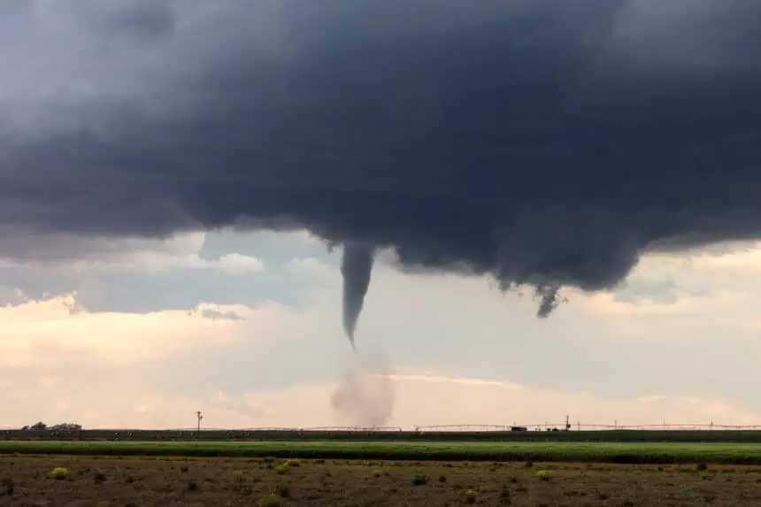
Multiple tornadoes reported, from EF-Unknown to EF-2
The storm began with a brief tornado over northwestern Cochran County, which remained over open land and caused no known damage. Shortly after, a strong EF-2 wedge tornado tracked eastward, destroying large wooden power poles and crossing TX-214, north of Morton, before dissipating in northeastern Cochran County.
The supercell then moved into northwestern Hockley County, producing another strong but unrated tornado near Pettit, followed minutes later by a brief cone-type tornado just north of the same area.
US-385 tornado overturns truck and destroys structures
The storm’s next tornado, rated EF-2, formed near Whitharral and crossed US-385, rolling a semi-truck, snapping power poles, and damaging multiple buildings and trees. This tornado remained on the ground for nearly 9.3 miles, with winds peaking at 125 mph (201 km/h).
Smyer and Reese Center hit by three tornadoes, including EF-2
As the system neared Lubbock County, it spawned three more tornadoes. The first Smyer tornado, rated EF-1, tore through a manufactured home community, injuring two people. Immediately after, a second, stronger EF-2 tornado developed and tracked southeast, destroying another manufactured home and damaging structures near TX-114 and FM 2378.
The final tornado, rated EF-1, touched down in Reese Center, toppling trees and damaging roofs before dissipating just outside the Lubbock city limits.
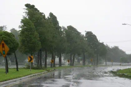
Severe downburst winds and large hail batter Lubbock
Even after tornado activity ceased, the supercell unleashed straight-line winds up to 115 mph (185 km/h) and hail up to 2.5 inches (6.35 cm) across western and southwestern Lubbock. The most severe damage was reported north of TX-114, with broken windows, roof damage, and tree debris scattered as far south as Wolfforth and east to Avenue Q.
Peak gusts recorded by the West Texas Mesonet reached 80 mph (129 km/h), contributing to extensive residential and commercial losses.
Enhanced Fujita ratings assigned by NWS
Of the eight confirmed tornadoes, three were rated EF-2, two were EF-1, and three remained unrated due to the absence of observable damage despite radar-confirmed rotation and spotter reports. Each tornado’s path and estimated wind speed were carefully surveyed based on KLBB WSR-88D, NSSL RaXPol radar, and on-ground inspection.
The largest tornado, the Whitharral EF-2, had a path width of 1936 yards (1.1 miles or 1.77 km), while the longest track belonged to the northern Cochran County EF-2, spanning 10 miles (16.1 km).
Tornadoes confirmed by the National Weather Service
Cochran County:
- Northwest Cochran Tornado: EF-Unknown, 2.54 miles
- Northern Cochran Tornado: EF-2, 10 miles
Hockley County:
- Northwest Hockley Tornado: EF-Unknown, 4.93 miles
- Pettit Tornado: EF-Unknown, 0.90 miles
- Whitharral Tornado: EF-2, 9.34 miles
- First Smyer Tornado: EF-1, 3.72 miles
- Second Smyer Tornado: EF-2, 3.35 miles
Lubbock County:
- Reese Center Tornado: EF-1, 2.65 miles
Straight-line wind and hail damage details
- Max wind gusts: 115 mph (185 km/h)
- Hail size: up to 2.5 inches (6.35 cm)
- Damage path: 7 miles long, 6 miles wide
- Most affected areas: Wolfforth, West Lubbock, Central Lubbock, north of TX-114
The National Weather Service emphasized that the combination of tornadic activity and downburst winds during this supercell event was among the most destructive in the Lubbock area in recent years.


